Topographic Surveys with a Record Boundary
Topographic Surveys with a Record Boundary
The Architect and the Land Surveyor
Last August we introduced a 4-part blog series,
What are the 5 Most Common Types of Surveys? The Architect and the Land Surveyor, with the goal of providing guidance and input on the many types of land surveys, and to help Architects and clients to better understand the value and requirements of the various types of land surveys. This month, we will focus on Topographic Surveys with a Record Boundary.
A topographic survey is the most common type of land survey utilized in development and subdivision of properties. They provide the basic existing site information needed for an architect to design an effective development plan for the property. Topographic surveys are often required for both simple projects, such as a residential room addition and for complex subdivisions and commercial developments.
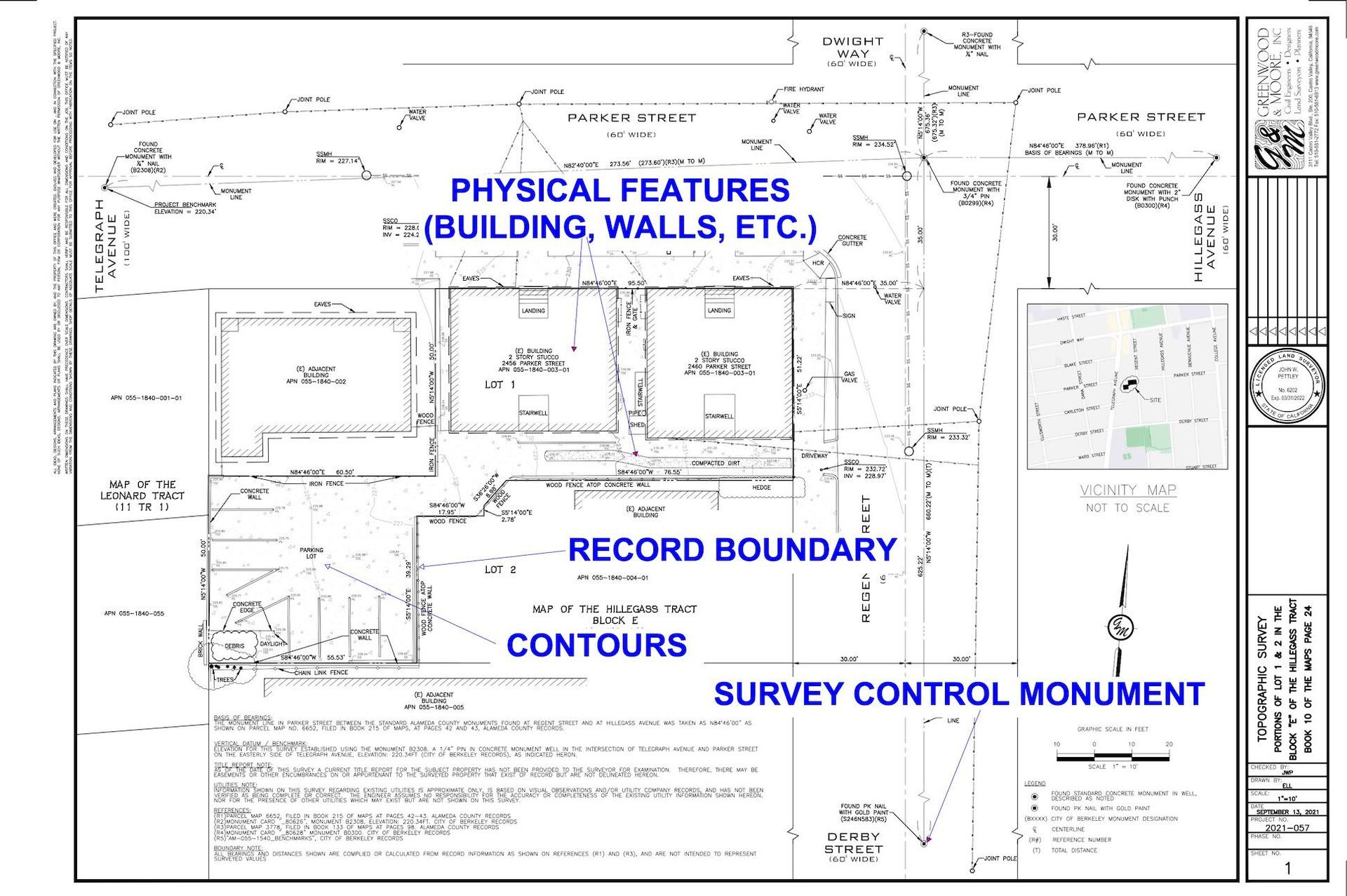
- Topographical Information is measurements of visible physical features such as buildings, fences, sidewalks, swimming pools, surface utilities, etc. These are the features you can “see and touch.” A topographic survey also includes “vertical elevation” or commonly referred to as the “contour lines.” This vertical elevation data provides critical information on the “slope” or “steepness” of the property. Also noted on the document are the Record Boundary and the Survey Control Monument.
- The Record Boundary is the physical location where the legal property line resides relative to the topographical physical features. For an architect, record boundary lines are critical to determine setback requirements and other important site development information.
- Contours identify if the property is flat, hilly, or steep.
- Survey Control Monument provides both horizontal and vertical control.
Requesting a Topographic Survey – Potential Pitfalls
It’s like buying a car! You can buy the basic model, or you can request all sorts of “bells and whistles.” Information that is frequently not included in a basic survey is listed below. It is important that an architect is aware of these additional features when requesting a topographic survey.
Occasionally, a surveyor may limit what is included in a topographic survey to keep the price down. Be prepared to specify exactly what you want included in the survey. If you’re not sure what to include, seek information from your land surveyor.
- Location and size of underground utilities. This may require the need for a third-party utility location company.
- Invert elevations (depths) of on-site and off-site utilities such as sewer manholes and storm drains.
- Surveying adjacent properties.
- Surveying within creek areas.
- Location and identification of tree species and sizes. Often, an arborist would be required if this is needed.
- Heights of existing buildings.
Research Required – Potential Problems
On the surface, the concept of a topographic survey is quite simple. The measurement of the topography is typically the easy part. Next comes the
record boundary. This is an important definition to understand. To locate the property line, obtaining the property’s deed is required; whereby the deed provides the legal description and the property dimensions.
A common and least expensive way to locate a property line is for the surveyor to use information from the deed. The surveyor will use the deed to compile (through mathematical calculations + field measurements of survey control monuments), the locations of the “record boundary” lines in relationship to the physical features on the site.
If there are discrepancies in the legal description, compiling the record boundary can cause difficulties. In this case, the surveyor must locate the record boundary in relationship to known “survey control monuments.” These monuments are fixed points, with defined coordinates in the area. Local municipalities will have records of the survey control monuments.
Other potential problems arise when the existing survey control monuments are missing or “paved over” with asphalt. It is common for the land surveyor to discover math errors in the legal description and other public documentation used to establish the record boundary.
If the land surveyor discovers a significant error in the boundary, then he/she will not be able to use a record boundary and will need to prepare a different type of survey, called a
boundary survey. A boundary survey is a more formal type of map that is used to resolve discrepancies in a boundary.
Architect’s Topographic Survey Request Checklist
- Request a “preliminary title report” from client prior to the survey request. This is a critical document that the land surveyor will need to establish any type of boundary information.
- Provide a map of the area that needs to be surveyed.
- Determine if the survey needs to include areas outside of the property boundary (adjacent properties, in the street, etc.)
- Request that utilities be located and identified (or not).
- Describe any special requirements that may be needed. If you’re not sure, contact the land surveyor for suggestions.
Key Takeaways
Topographic surveys are a critical part of many development projects. This article is intended to provide architects with a basic understanding of the major components of topographic surveys and common problems that may arise during their preparation. This allows the architect to educate their clients about survey requirements, potential issues, and initial costs at the beginning of the project. By understanding the basic requirements of topographic surveys, the architect will be able to avoid common pitfalls and reduce the chance of unpleasant surprises for their clients.
Next Series Topic: The Boundary Survey, The Corner Record, and the Record of Survey
As you may guess, a boundary survey is more time-consuming and is often much more expensive. Boundary surveys must also be submitted to the local municipality’s Surveyor’s office for review and approval. All boundary surveys must be officially filed and recorded in the public record in the County in which it was prepared.
When a boundary survey becomes necessary, the Surveyor will provide a budget and price to resolve the problem. The Surveyor should also explain to the architect/owner why it is necessary, and what the problems could be.
Greenwood & Moore, Inc. (G&M) Is Your Partner
Always keep in mind, that G&M is your partner when you look to determine your client’s requirements and needs for a land survey. We do hope this ongoing series continues to build a solid foundation for discussions on your upcoming projects. And, next month we’ll focus on the
Boundary Survey, along with a simple
Corner Record and a complex
Record of Survey.
Since 1994, G&M’s goal is to “Make our Clients' Vision a Reality."